June 1 marks the official start of the 2023 hurricane season and The University of Alabama in Huntsville (UAH) Department of Atmospheric & Earth Science is ramping up its hurricane research.
Atmospheric scientists at UAH, a part of the University of Alabama System, are studying different characteristics of hurricanes such as lightning, cloud formation, and localized near-surface wind gusts to better predict the intensity of hurricanes before making landfall.
The greater the accuracy in forecasting hurricane intensity will allow atmospheric scientists to better message the potential devastation to the public and how to prepare accordingly.
“Hurricane winds can be stronger than tornadoes,” says Dr. Xiaomin Chen, assistant professor of UAH’s Department of Atmospheric & Earth Sciences.
A category 5 hurricane reaches a mean wind speed of 157 miles per hour as defined by the Saffir-Simpson hurricane wind scale.
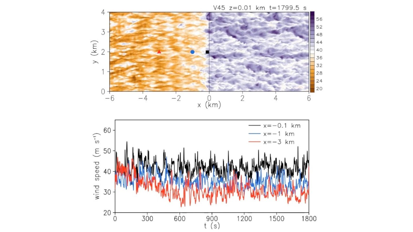
Dr. Xiaomin Chen, assistant professor of UAH’s Department of Atmospheric & Earth Sciences research focuses on turbulent processes that generate localized wind gusts from hurricanes in the boundary layer, also known as near-surface, the layer of the atmosphere we live in.
“Turbulence that rides along the mean wind speed can create localized gusts reaching even higher speeds than a category 5 hurricane,” says Chen.
Chen’s research focuses on turbulent processes that generate localized wind gusts from hurricanes in the boundary layer, also known as near-surface, the layer of the atmosphere we live in.
Very little data has been collected on boundary layer localized wind gusts as it’s not permitted for aircraft to fly that low to the ground. Researchers must be on the ground, in the path of a landfalling hurricane to collect real-time wind gusts.
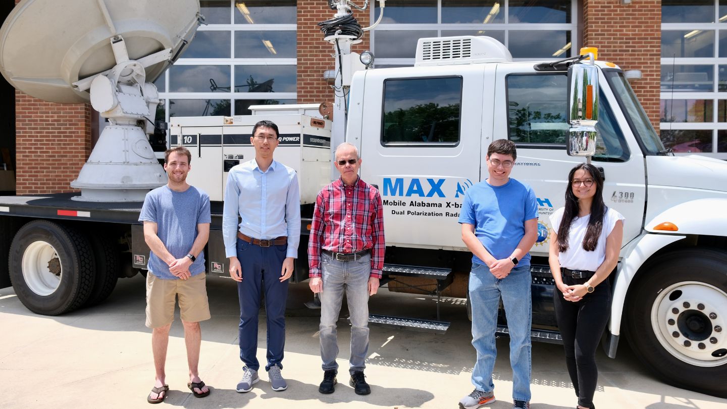
To expand upon the limited data on localized hurricane wind gusts, Chen, in collaboration with the Director of UAH’s Severe Weather Institute - Radar and Lightning Laboratories, Dr. Kevin Knupp, plans to deploy UAH’s Mobile Atmospheric Profiling Network’s fleet of research vehicles to collect real-time wind data on hurricanes anticipated to make landfall along the Gulf Coast this season. The Mobile Atmospheric Profiling Network is a National Science Foundation funded requestable facility that is part of the Community Instrument and Facility suite.
UAH’s research vehicles are equipped with weather instrumentation to collect real-time data of these localized wind gusts before and during a hurricane making landfall. Chen will form a team of UAH Department of Atmospheric & Earth Science undergraduate and graduate researchers to help deploy the research vehicles down to the Gulf Coasts and collect real-time data.
“It’s important to take advantage of any landfalling hurricane that occurs along the Gulf Coast in 2023, because it is a rare event. Our team will be trained to take the proper safety precautions during these deployments,” says Knupp.
With a National Science Foundation proposal in the works, Chen hopes success from hurricane deployments this year will lead to his boundary layer localized wind gust research being fully funded before the 2024 hurricane season begins.
From this proposal, Chen hopes UAH will collaborate with other universities and NOAA’s Hurricane Research Division to collect a variety of wind, temperature, and humidity data both offshore and onshore in multiple Gulf Coast locations that are impacted by future hurricanes.
In addition to studying localized wind gusts, UAH’s Department of Atmospheric & Earth Science graduate student Kiahna Mollette and undergraduate student John Mark Mayhall are working with NASA’s Short-term Prediction Research and Transition Center (SPoRT) to study characteristics of hurricanes that may spark rapid intensification. Through a cooperative agreement between UAH and NASA Marshall Space Flight Center, the two students work under NASA SPoRT’s Civil Servant, Dr. Patrick Duran.
“Currently, it’s difficult to determine what the intensity of a hurricane will be at landfall, especially since rapid intensification is determined over a 24-hour period,” says Mollette.
The National Hurricane Center defines rapid intensification as a change in sustained winds of 30 knots in 24 hours. The National Hurricane Center is working to improve its hurricane intensity forecast as sometimes hurricanes can rapidly intensify in less than 24 hours.
In her research, Mollette uses data from NOAA’s Geostationary Lightning Mapper aboard the GOES East satellite to study the brightness of lightning flashes that occur in the inner eyewall of a hurricane and its relationship to hurricane intensity. The brightness of a lightning flash is known as optical energy.
“By studying the relationship of optical energy and hurricane rapid intensification, we may be able to observe a hurricane intensifying in near real-time, thus allowing operational weather forecasters to provide more lead time to the public of how strong a hurricane will be once it makes landfall,” says Mollette.
Mollette is currently studying past hurricanes including Laura, Dorian, and most recently Hurricane Ian of 2022. She hopes the 2023 hurricane season will add more case studies for her research.
Mayhall is studying whether bands of cirrus clouds generated from a hurricane’s outflow indicate changes in the storm's size and structure.
“When a hurricane begins to strengthen, a lot of air is evacuated from the eyewall and pushed outward from the hurricane in all different directions, creating what’s called an outflow. This outflow of air can create bands of cirrus clouds,” says Mayhall.
Mayhall states the tricky part of his research is bands of cirrus clouds can be produced by hurricanes in multiple ways, not just from outflows of hurricanes.
“My goal is to see if there is a relationship between rapid intensification and cirrus clouds forming. I hope to examine cirrus clouds that develop from hurricane outflows during the 2023 season to further validate my research,” says Mayhall.
UAH researchers will be closely monitoring the potential of hurricanes for nearly six months as hurricane season runs from June 1st to November 30th each year.