Written by: Brianne Minton
With Technical Expertise From: Dr. Rob Junod, Michael Solomon, & Dr. Lee Ellenburg
If you live in Alabama, you have likely heard the phrase “Respect the Polygon.” Made popular by James Spann, it refers to the warning shapes issued by the National Weather Service (NWS) that outline where dangerous weather is expected or already occurring. During severe weather seasons, these polygons become a regular part of daily life, and staying updated as they change in real time is an important part of tracking active storm systems and understanding your risk.
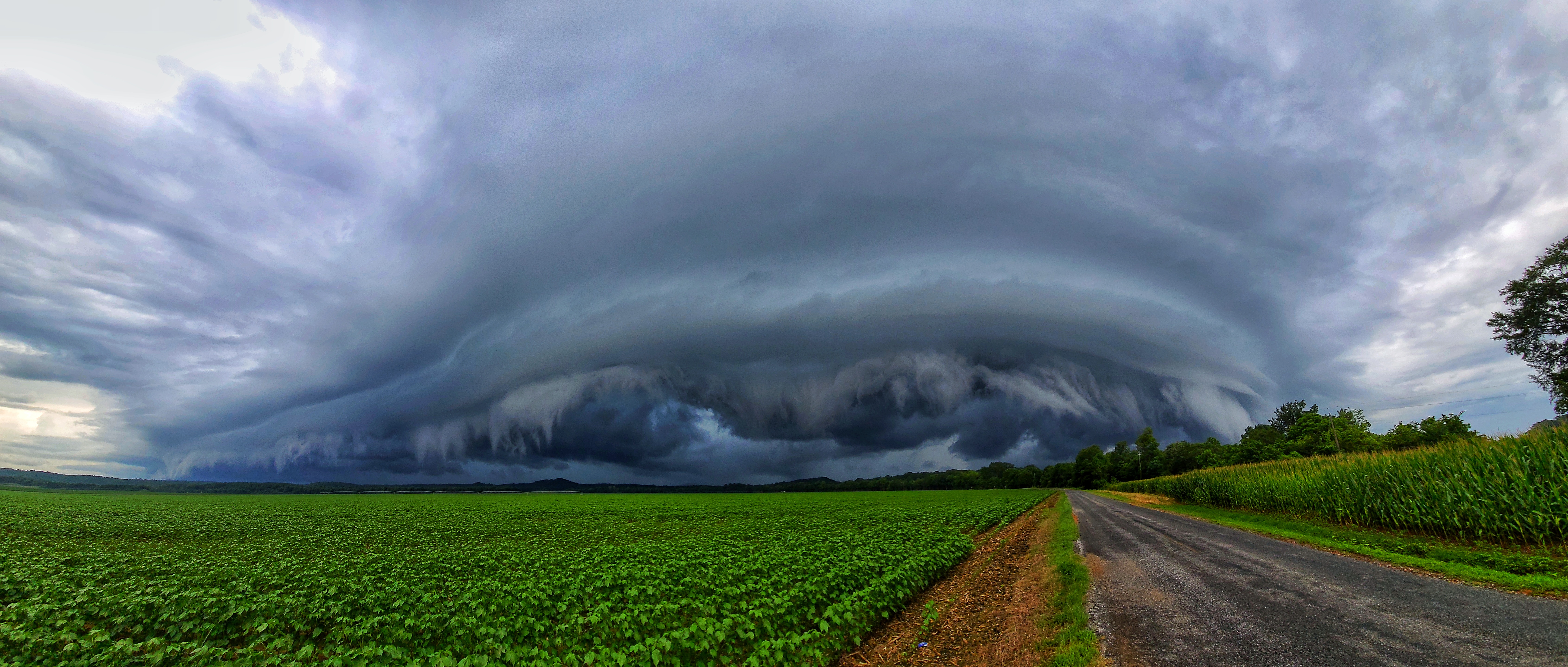
As Alabama moves into peak severe weather season, a time of year associated with more frequent hazardous weather, it is important to increase weather awareness. April 27, 2011 is a day many Alabamians will never forget as multiple waves of tornado-producing storms moved across the state, leaving lasting impacts on communities, families, and the landscape itself. While events of that magnitude are rare, they highlight how important it is to understand tornadoes - how they form and how they behave across our state. To keep things readable, some of the science to follow is simplified, but this blog provides a solid starting point for understanding how these storms develop and why they can be so impactful in Alabama.
What is a tornado?
The American Meteorological Society provides standard definitions for many weather terms, and the following are commonly used when discussing tornadoes.
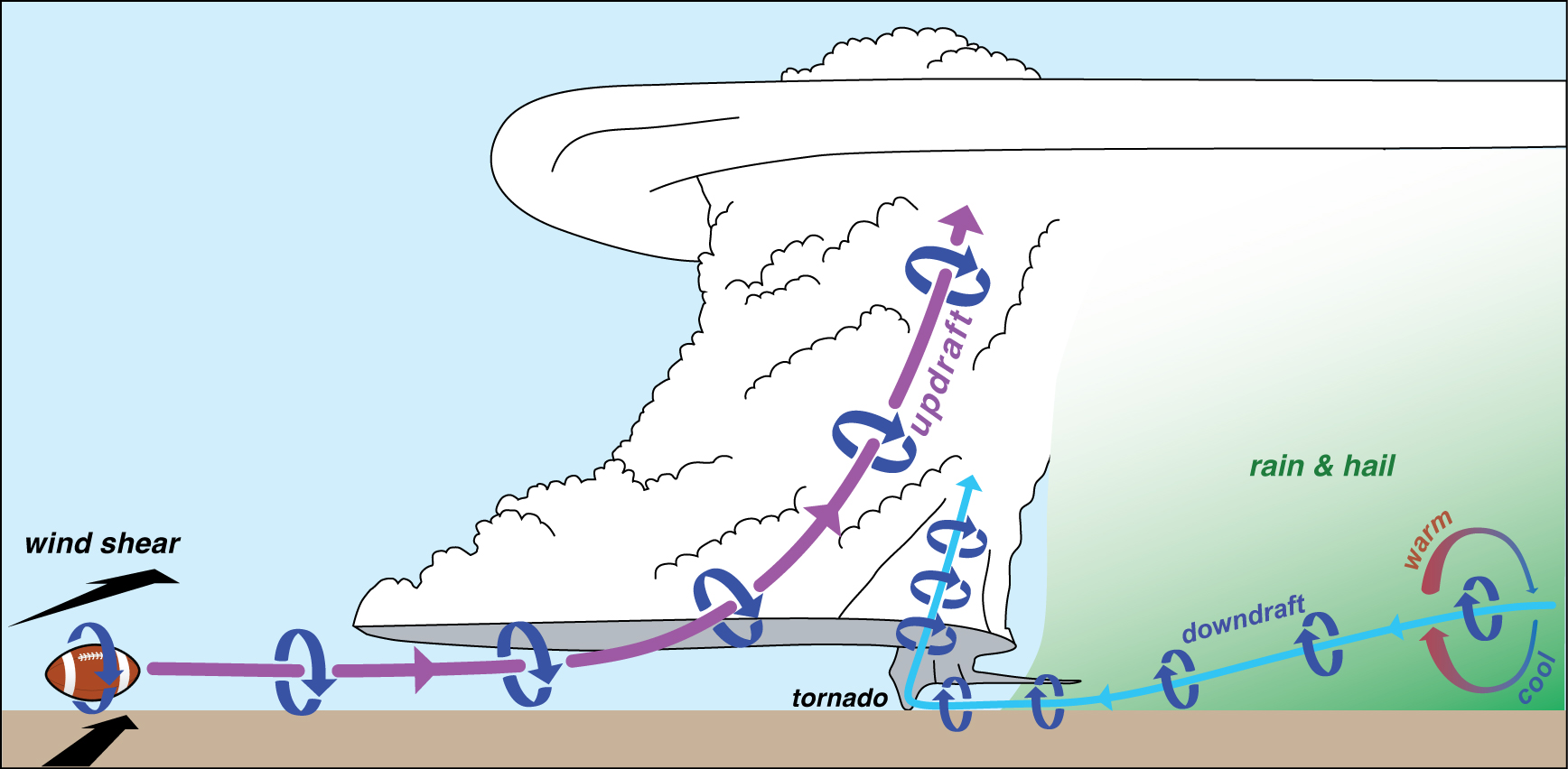
- A supercell is a thunderstorm with a deep, persistent rotating updraft. This rotating core, called a mesocyclone, allows the storm to organize and sustain itself over time and is the type of storm most commonly associated with tornadoes.
- A funnel cloud is a rotating condensation cloud that extends from a storm but does not reach the ground. While it may look like a tornado, it is only classified as one if the rotation is in contact with the surface.
- A tornado is a rapidly rotating column of air extending vertically from the surface to the base of a cloud. While many tornadoes are visible as a funnel-shaped cloud, the visible funnel is not required for a tornado to exist, since the rotation at the surface is what defines it.
- The Enhanced Fujita (EF) Scale is used to rate tornado strength based on the damage left behind after a storm. The scale ranges from EF0 (weaker) to EF5 (stronger). Weaker tornadoes are more common, but they can still cause damage, and impacts often increase as tornadoes become stronger and larger.
How do tornadoes form?
Tornadoes form when certain atmospheric conditions come together, but even when those conditions are present, not every storm produces a tornado. In many cases, tornadoes develop from supercells, where strong rotation is already established within the storm.
During these storms, warm, moist air near the ground is pulled into the storm while cooler, denser air sinks toward the ground in downdrafts. At the same time, winds are changing speed and direction with height, a process known as wind shear. This combination can cause the air near the surface to begin rotating, creating spinning air at the ground that is already considered tornadic activity.
At the same time, a funnel cloud begins to form within the supercell and extends downward from the storm. This funnel is the visible feature most people associate with a tornado, but it is actually just condensed water vapor and is not the tornado itself.
When the funnel cloud connects with the rotating air at the ground, the system becomes fully linked. The horizontal rotation at the ground’s surface is lifted and turned vertically into the storm, creating a stronger and more organized column of rotating air. This is why tornadoes are more accurately described as “spin-ups” rather than “touchdowns.” Even though it appears that they are coming down from the cloud, the tornado is actually happening at the ground and building upward into the atmosphere as the funnel cloud develops.
Once this connection is established and sustained, a tornado is present. These same storms often produce damaging straight-line winds and large hail, which can increase the overall impacts of a severe weather event even outside of the tornado itself. In Alabama, this setup happens often when warm, humid air from the Gulf of Mexico moves north and interacts with cooler air and stronger winds in the atmosphere, supporting thunderstorms capable of producing tornadoes and other severe weather hazards.
Alabama tornado facts
The maps and figures below highlight how tornadoes, wind, and hail behave across Alabama based on long-term records from the Storm Prediction Center. These graphics focus on patterns, frequency, timing, and impacts, not just individual storms.
Where do tornadoes occur most often?
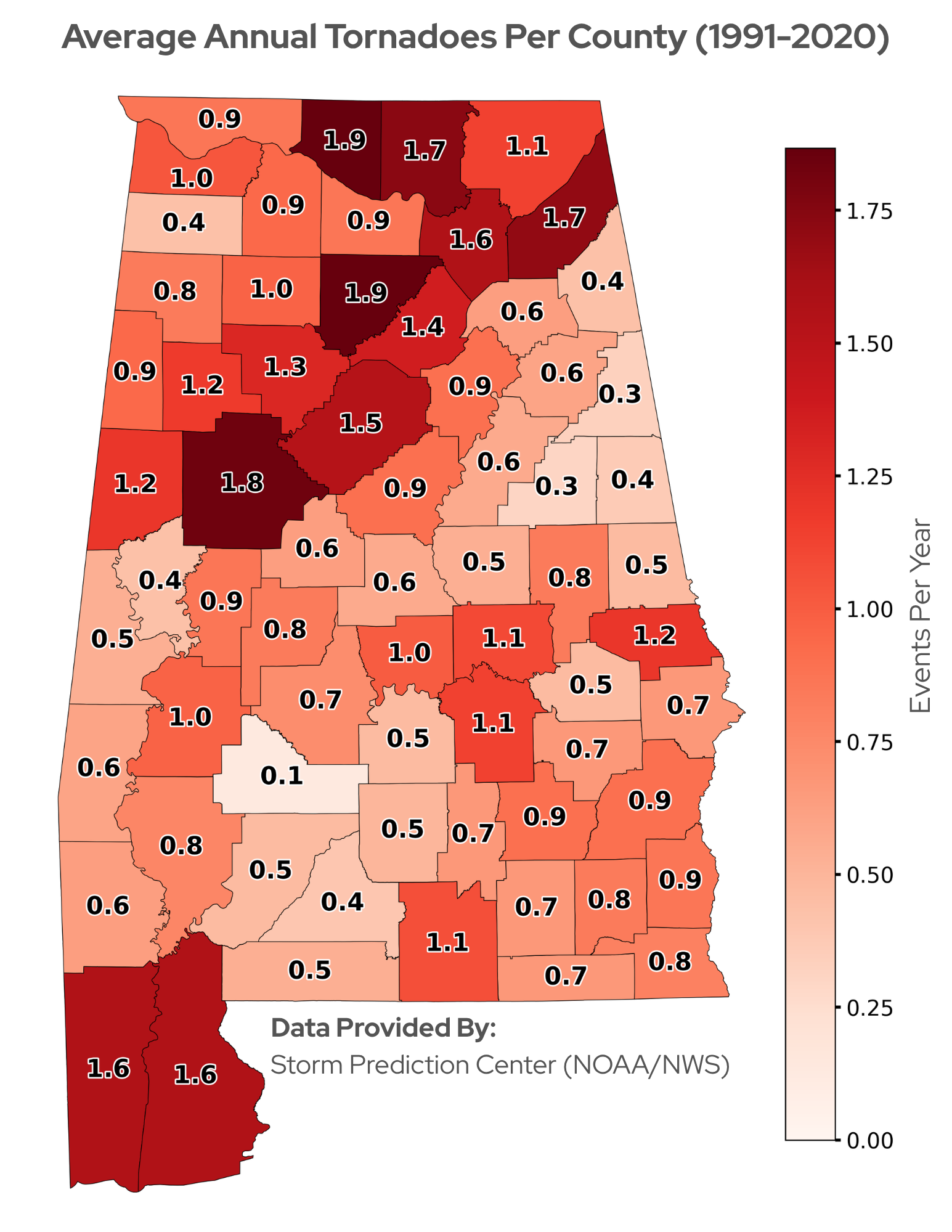
- These values show the average number of tornadoes reported per county each year from 1991–2020, regardless of severity.
- The highest average tornado counts occur in North Alabama, including Limestone, Cullman, Madison, and DeKalb counties.
- Tuscaloosa County also ranks among the highest, and the Gulf Coast, especially Baldwin and Mobile counties, shows elevated activity.
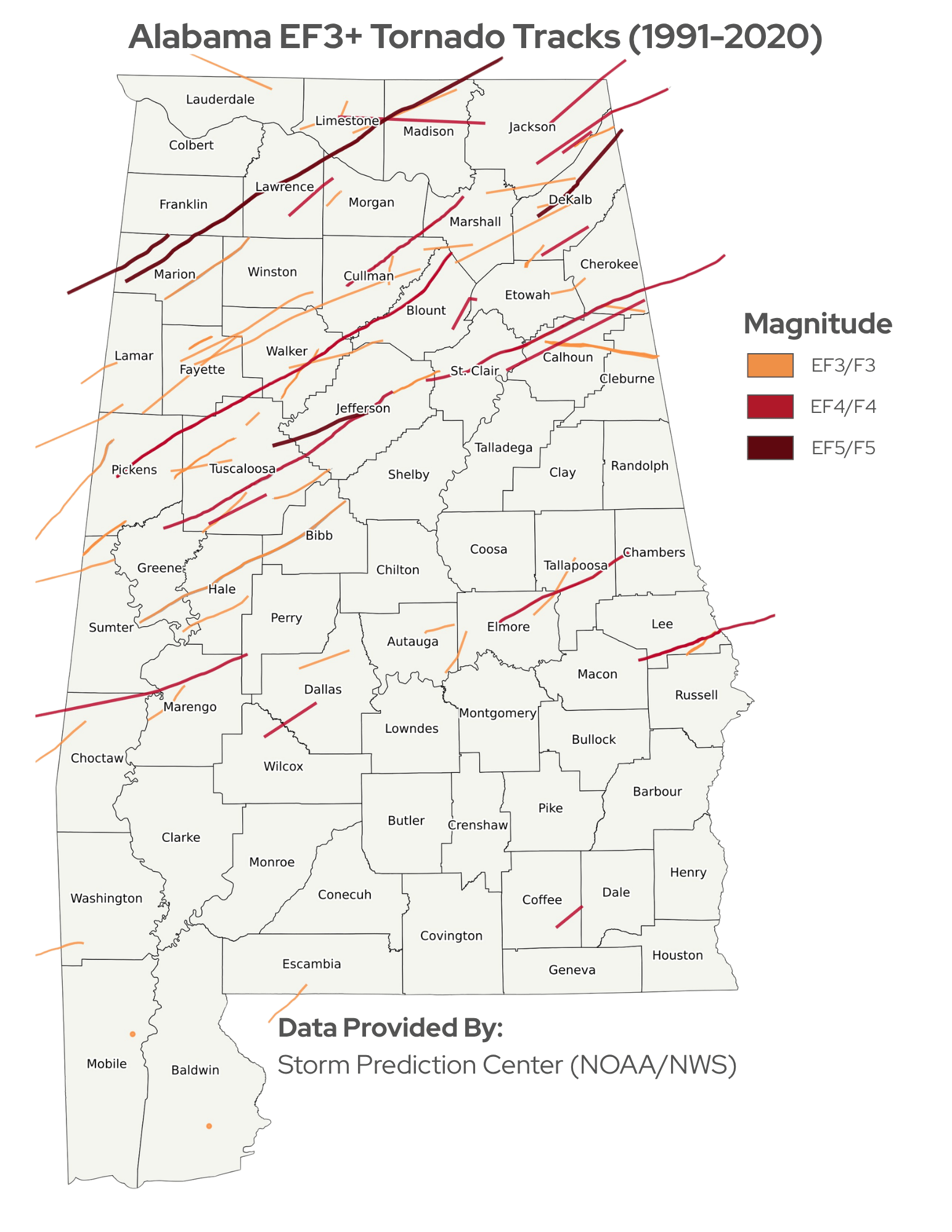
- Tracks shown on the EF3+ map only include tornadoes rated EF3 or stronger. Track segments outside Alabama are not shown, so some paths may be longer than what appears on the map.
- Most EF3+ tornado tracks occur north of Tuscaloosa, but several have also crossed the Black Belt region.
How strong are Alabama tornadoes?
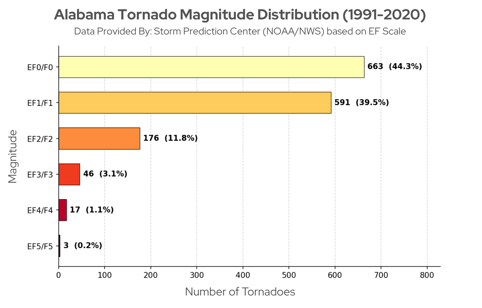
- Most tornadoes recorded in Alabama from 1991–2020 were EF0 or EF1, making up more than 80 percent of all events.
- EF2 tornadoes account for a smaller share, while EF3 and stronger tornadoes are much less common.
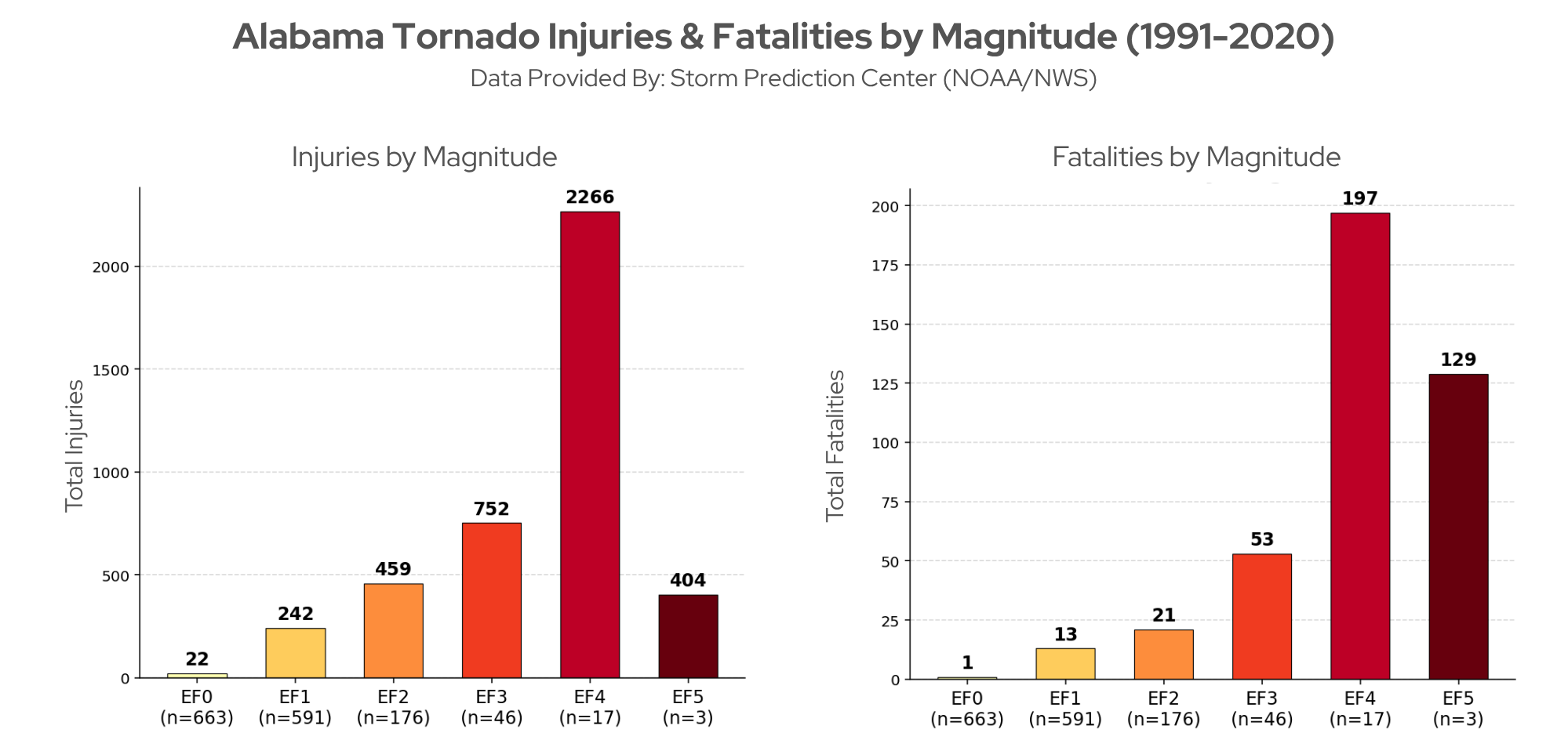
- Even though the strongest tornadoes are rare, their impacts are often much greater. Injuries and fatalities generally increase as tornado intensity increases.
- From 1991–2020, EF4 tornadoes accounted for the highest number of injuries and fatalities in Alabama.
When do tornadoes happen?
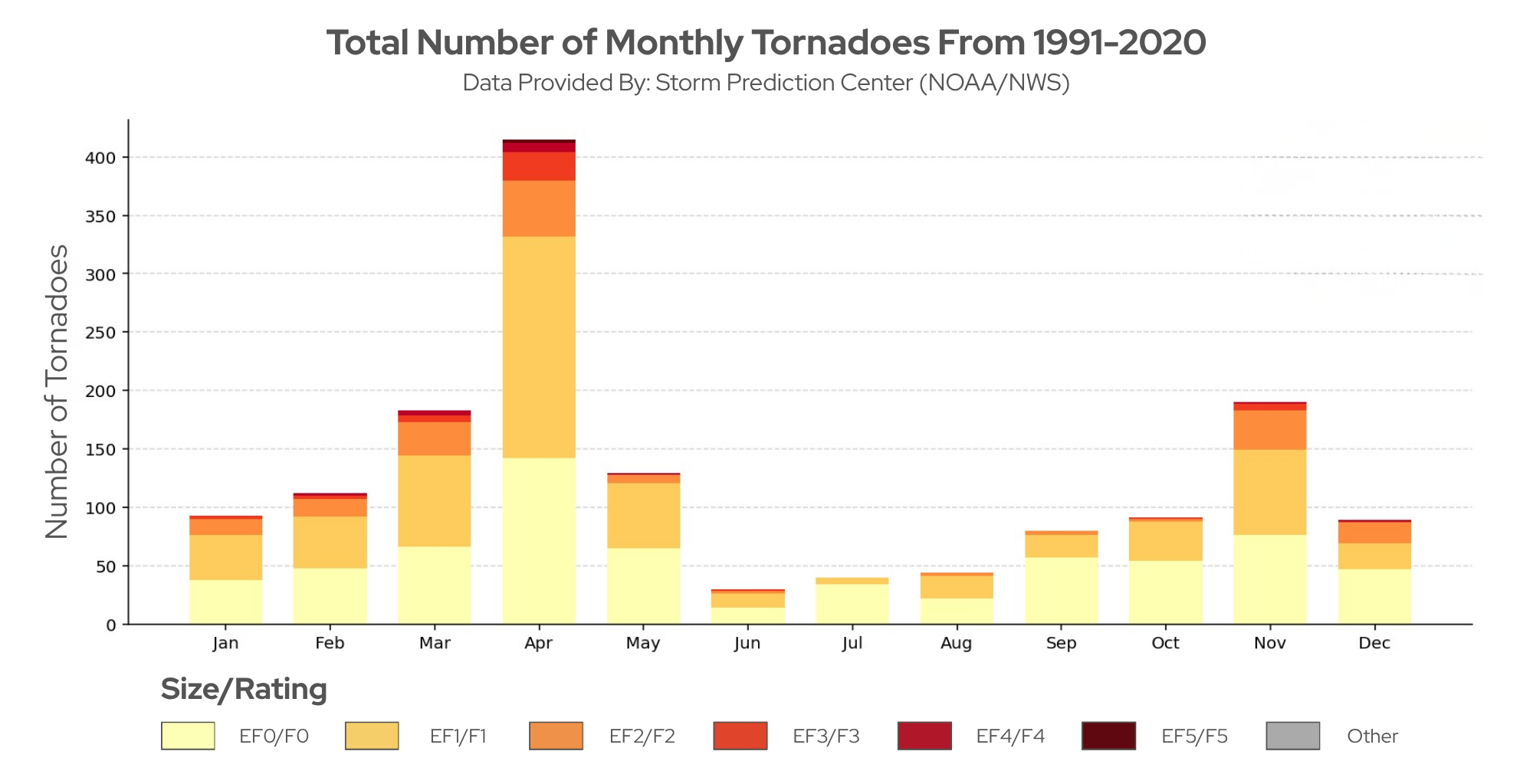
- April historically has the highest number of tornadoes, with over 400 events in the past 30 years. April sees an increase in storm systems that are favorable for tornado formation and experiences 13.8 tornadoes on average
- November is the second most active month, highlighting Alabama’s well-known fall severe weather season.
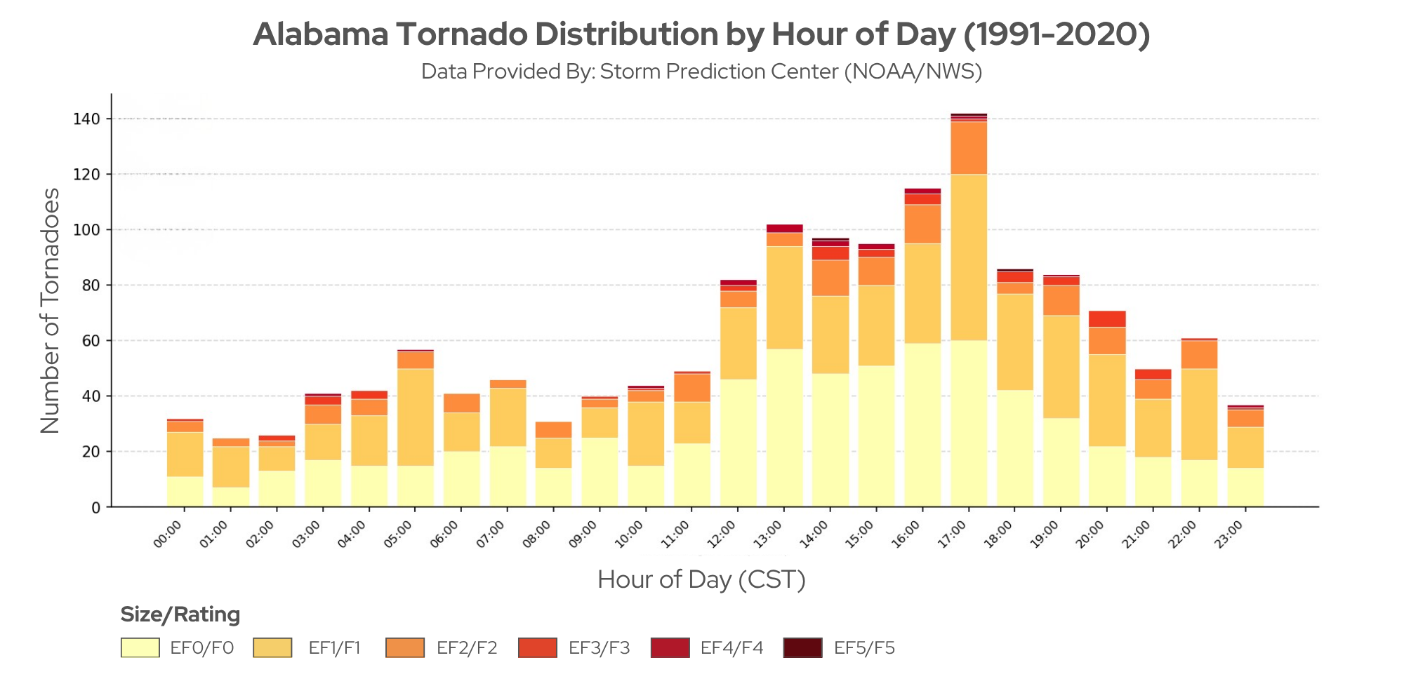
- Most tornadoes occur in the afternoon and evening, with activity peaking around 5 PM CST.
- A notable number also occur overnight, which increases risk because tornadoes are harder to see and people are more likely to be asleep when warnings are issued.
Wind and hail patterns
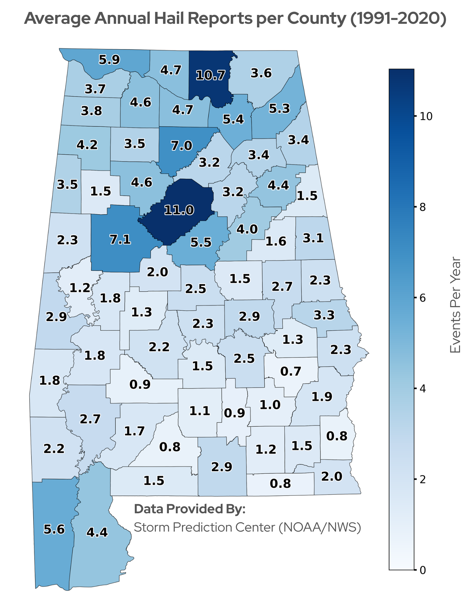
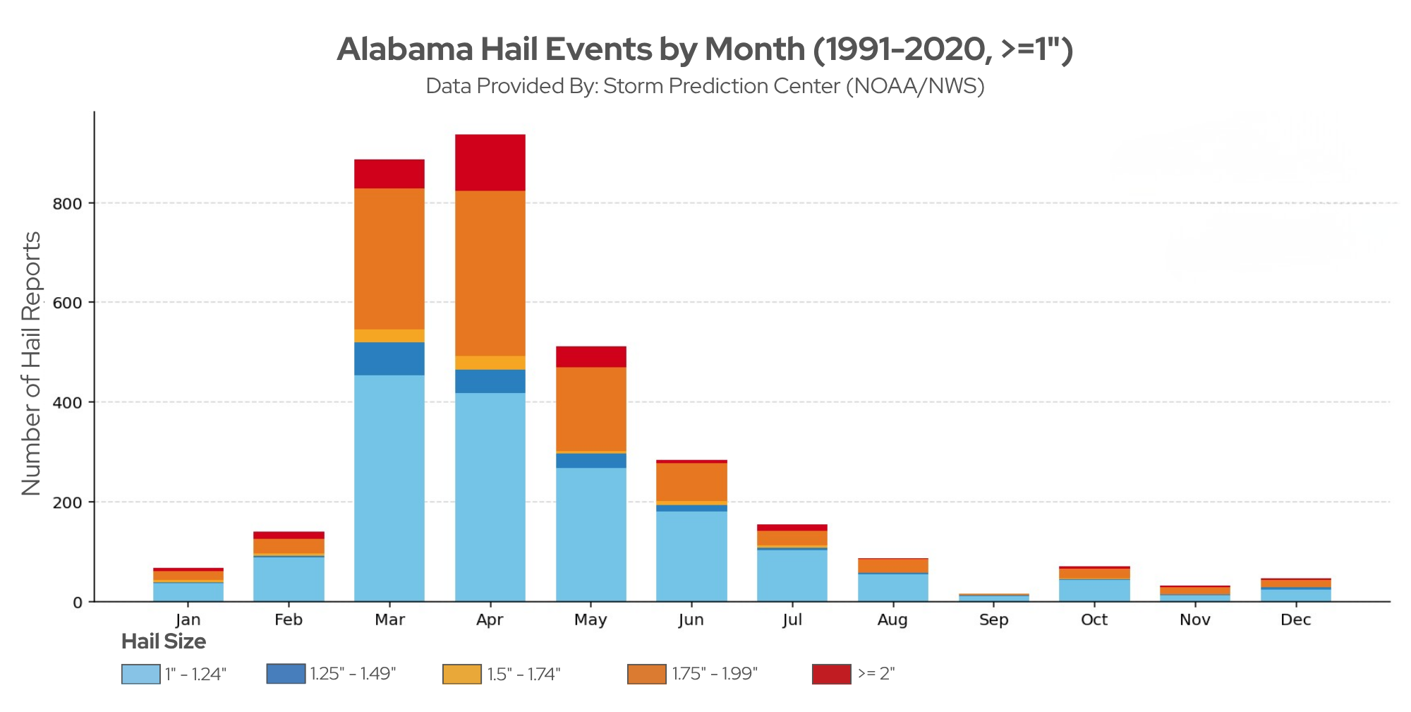
- This hail data only includes hail that is 1 inch or greater, because that meets the threshold for a severe thunderstorm warning. Smaller hail has occurred in Alabama, but it is not accounted for here.
- The highest average hail activity has occurred in Jefferson and Madison counties, with more than 5 severe hail events per year.
- Similar to tornado patterns, hail activity is generally higher across North Alabama and along parts of the Gulf Coast.
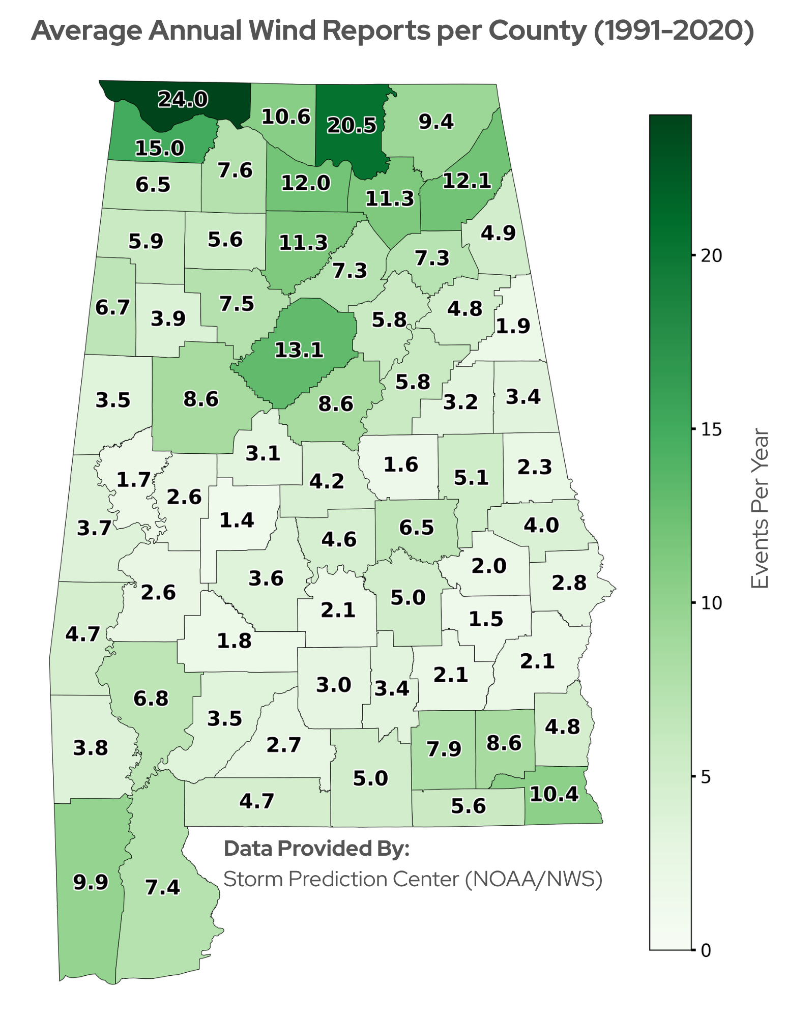
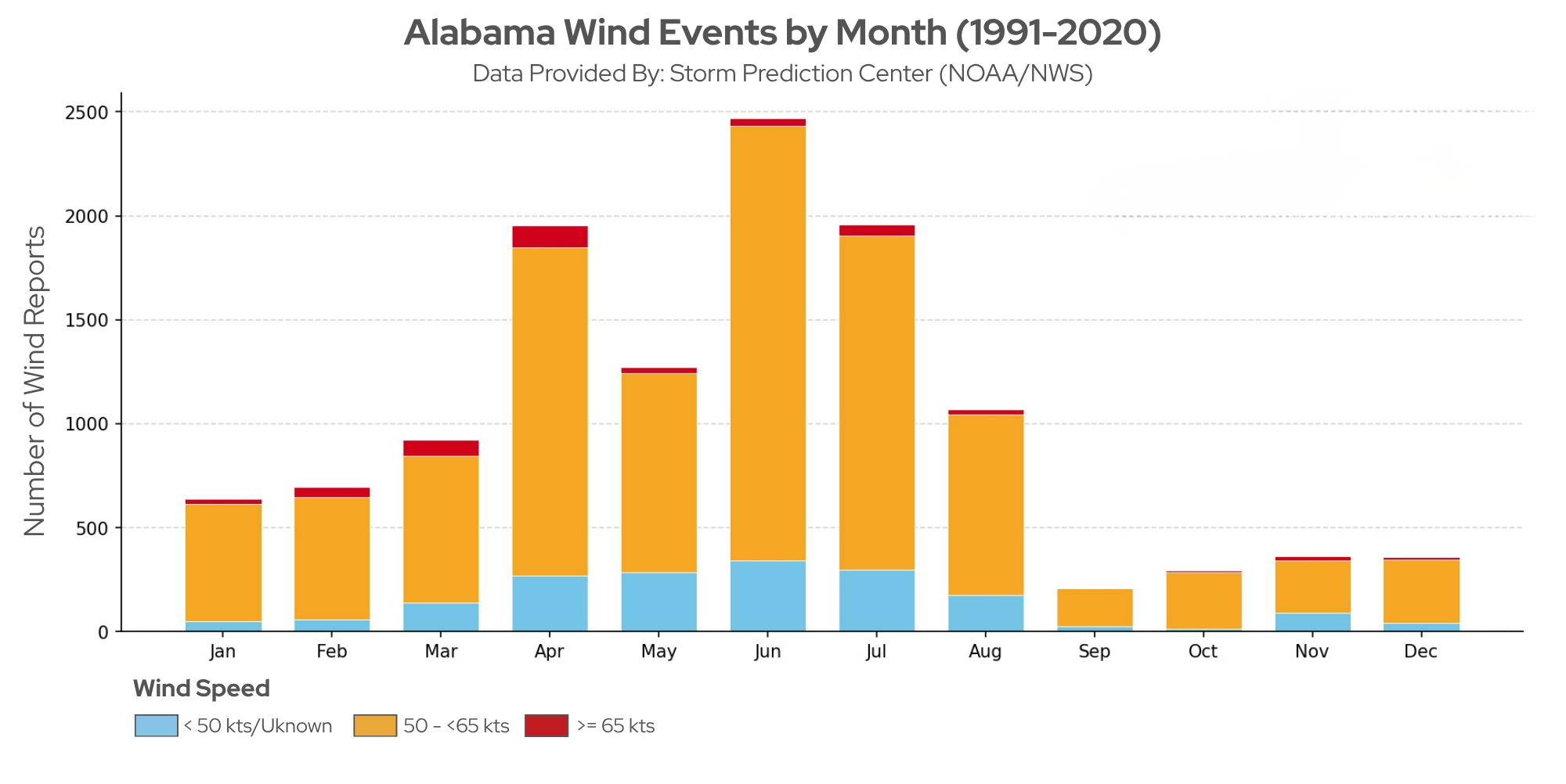
- These wind reports include events associated with damage and or meeting severe thunderstorm criteria of 58 mph or greater.
- Even though tornado activity peaks in spring, damaging wind reports are higher in June. This is partly because summer thunderstorms can produce strong straight-line winds, often from microbursts, over 58 mph without the conditions needed to form tornadoes.
- Lauderdale and Madison counties report some of the highest average annual damaging wind activity in the state.
- Most damaging wind reports occur across North Alabama, with additional pockets of higher activity along the Gulf Coast and in Southeast Alabama.
Watches, warnings, and staying informed
The NWS uses watches and warnings to communicate tornado risk, and understanding the difference is an important part of staying informed. A tornado watch means conditions are favorable for tornadoes to develop, while a tornado warning means a tornado has been sighted or indicated on a weather radar. A tornado emergency, the highest alert level, is issued when a large, destructive tornado is confirmed and capable of causing catastrophic damage in a populated area. The NWS also issues severe thunderstorm warnings for storms producing wind gusts of 58 mph or greater and/or hail at least 1 inch in diameter.
In Alabama, tornadoes can occur at any time of day, including overnight hours when they are harder to detect and respond to. And they often occur in high precipitation events, where tornado visibility is much lower. Having multiple ways to receive warnings, such as a battery operated weather radio and wireless emergency alerts on your phone, can help ensure you receive timely information, especially at night. It is also important to have a severe weather plan in place so you know where to go and what to do when warnings are issued. Visit your local NWS office webpage for the latest forecasts, watches, and when severe weather is in the forecast, remember to respect the polygon.
Contacts
Alabama Office of the State Climatologist - aosc@uah.edu
Huntsville NWS Forecast Office
Birmingham NWS Forecast Office
Mobile/Pensacola NWS Forecast Office
Tallahassee NWS Forecast Office