UAH researcher helps uncover “burn scar heat islands,” advancing understanding of wildfire impacts on weather
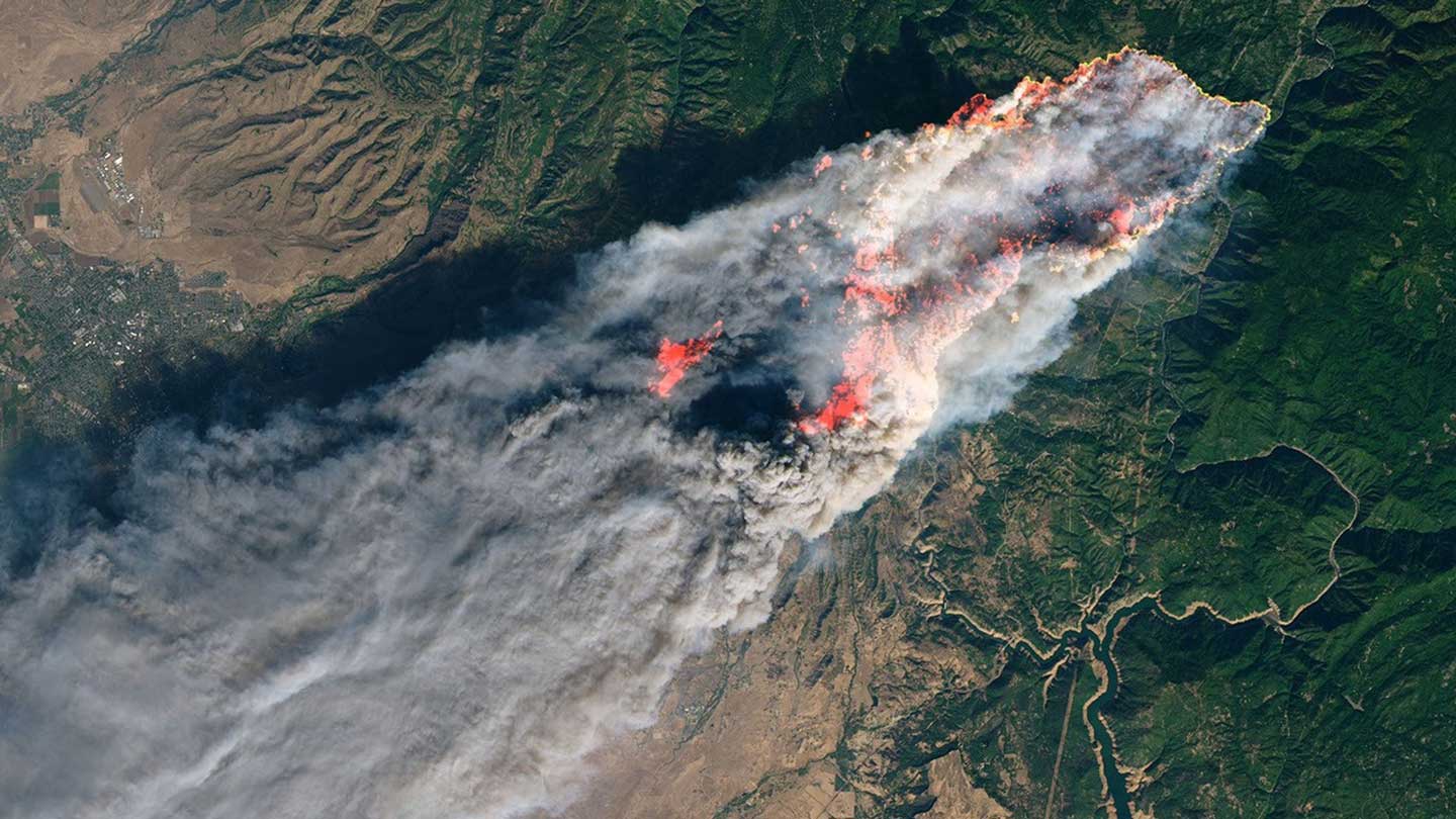
NASA satellites captured dramatic imagery of the 2018 Camp Fire in California, showing massive smoke plumes, burn scars and damage assessments from space.
New research headed by a University of Alabama in Huntsville (UAH) scientist working in collaboration with NASA reveals that wildfires can leave behind more than scorched Earth – they can create persistent “heat islands” that reshape local weather patterns long after the flames are extinguished. The study, published in the Bulletin of the American Meteorological Society (AMS), was led by Andrew Blackford, a UAH Earth System Science Center (ESSC) researcher affiliated with NASA’s Marshall Space Flight Center. The work provides one of the most comprehensive analyses to date of how wildfire burn scars alter interactions between the land surface and the atmosphere. UAH is a part of The University of Alabama System.
Using the devastating 2018 Camp Fire in California as a case study, the research combines satellite observations with advanced numerical weather modeling to show that burned landscapes can become significantly hotter and drier than surrounding areas—forming what scientists describe as “burn scar heat islands.”
“These effects are similar in concept to urban heat islands, but they’re driven by wildfire-induced changes to the land surface,” Blackford explains.

Andrew Blackford, a research associate IV with UAH’s Earth System Science Center.
Wildfires strip away vegetation, darken soils and reduce the land’s ability to retain moisture. The study found that these changes dramatically alter how energy moves between the Earth and the atmosphere.
Despite a decrease in overall surface radiation, the researchers observed an increase in sensible heat—the direct transfer of heat from the Earth into the air. This leads to warmer surface air temperatures and lower humidity over burned areas.
The study reveals that burn scars can have consequences that extend beyond temperature alone. These areas can increase near-surface air temperatures while simultaneously decreasing dewpoint, leading to drier atmospheric conditions. In addition, burn scars can strengthen localized wind circulations and play a role in influencing cloud formation and even broader rainfall patterns.
“These changes can persist well after the wildfire event, especially in regions with complex terrain,” Blackford notes. “They have important implications for post-fire recovery, hazard mitigation and weather forecasting.”
The work highlights the strength of collaboration between UAH and NASA, particularly through the NASA Visualization, Exploration and Data Analysis (VEDA) initiative. The project originated from a data-driven storytelling effort developed through VEDA that demonstrates how public-facing science communication can evolve into peer-reviewed research.
“I have been working with VEDA since the fall of 2022, first as a GRA then became full-time in the fall of 2024,” Blackford says. “The VEDA platform accelerates the data life cycle, where a wide variety of scientists can explore, research, publish and communicate their products. One unique aspect of the data stories is the ‘scrollytelling’ feature, which enables users to scroll through a series of complex factors involving a particular event to better understand what the data is telling us and how to transform that information into actionable insights.”
The Camp Fire study grew directly from that environment of exploration and innovation. “This is the first study to examine a burn scar’s effects on regional diurnal circulations, and is also the first time ‘burn scar heat island’ has been coined,” Blackford says. “I first began exploring this research idea after discussions with fellow meteorologists at the 2023 Annual AMS Conference.”
As wildfire frequency and intensity increase across the United States, understanding their long-term atmospheric impacts is becoming increasingly important. The findings suggest that post-fire landscapes should be considered in weather models, emergency planning and recovery strategies.
“This study shows that wildfire impacts extend beyond the immediate event,” says Dr. Udaysankar Nair, a UAH professor of Atmospheric and Earth Science and co-author of the study. “They fundamentally change how the land and atmosphere interact.”
Looking ahead, Blackford says his work will continue to focus on extreme weather and land-atmosphere interactions.
“As we go forward and technology continues to advance, I expect our understanding of these microscale and mesoscale processes and responses to severe weather events altering land use and land cover to continue increasing. Ultra-finescale numerical modeling combined with observational analysis of these responses will be crucial to our understanding.”
The research underscores UAH’s leadership role in Earth system science and its close partnership with NASA, advancing knowledge that not only deepens scientific understanding but also helps communities better prepare for natural hazards.