Written by: Dr. Lee Ellenburg, Dr. Rob Junod, & Brianne Minton
El Niño is back in the tropical Pacific and is expected to strengthen considerably over the coming months. This has generated plenty of discussion about what it could mean for weather across the United States, including here in Alabama. We have been getting many of the same questions: Will El Niño affect our temperatures and rainfall? Could it mean more snow? What about hurricanes?
First and foremost, El Niño is not a weather forecast. It does not tell us whether a particular day will be rainy, cold, or snowy. Instead, it shifts the odds toward certain weather patterns during particular times of the year. For Alabama, those shifts are real but generally modest, and they are most evident from late fall through early spring.
Here are some of the questions we hear most often, along with what historical data tell us about El Niño's influence on Alabama.
What Is ENSO?
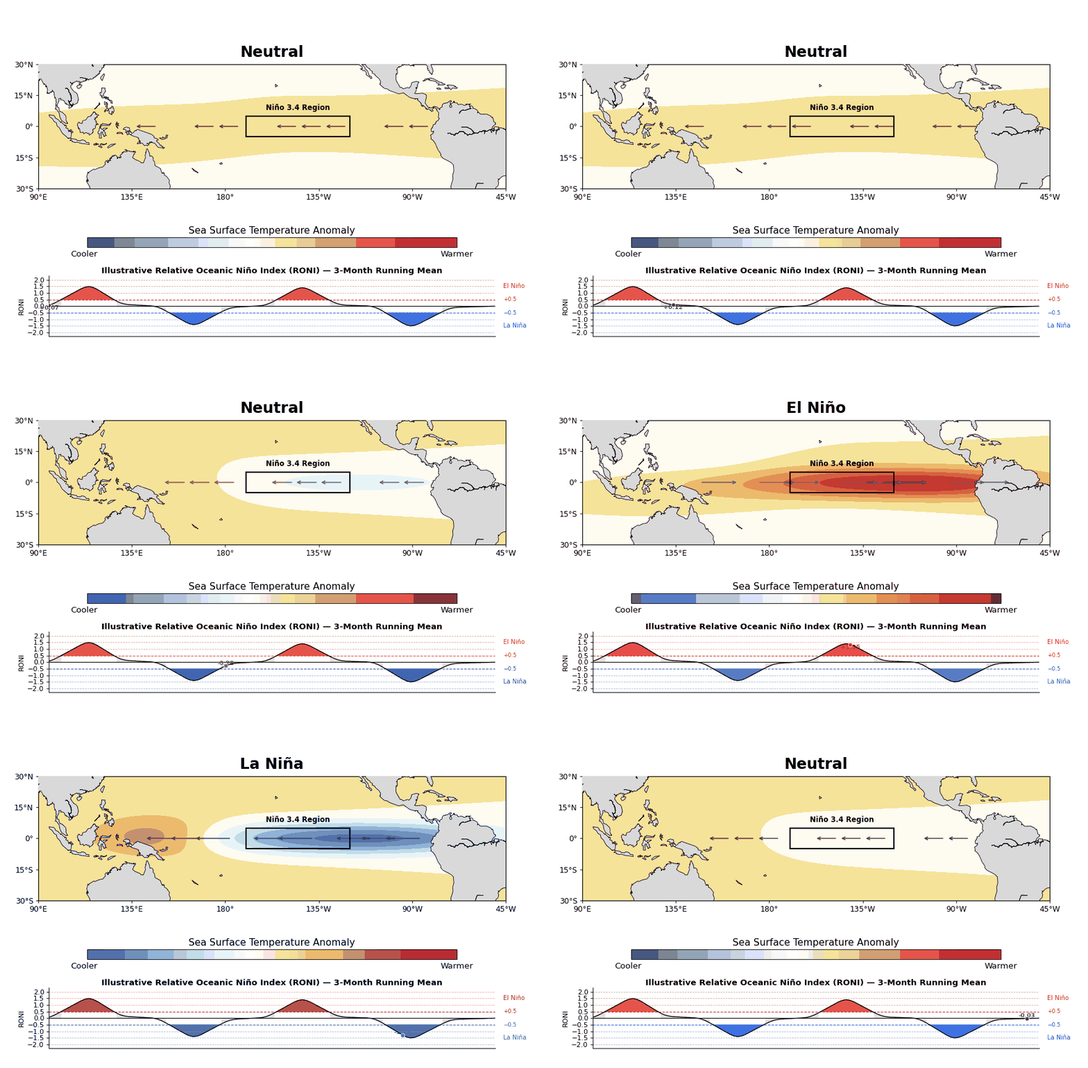
El Niño is one phase of the El Niño-Southern Oscillation, better known as ENSO.
ENSO describes changes in ocean temperatures and atmospheric circulation across the tropical Pacific Ocean. During El Niño, waters across the central and eastern equatorial Pacific become warmer than normal. During La Niña, they become cooler than normal. When neither condition is present, we call it ENSO-neutral.
Because the strength of ENSO can change over time, scientists closely monitor sea-surface temperatures in an area called the Niño 3.4 region. Changes there are one of the primary indicators used to track the development and strength of El Niño and La Niña.
At first glance, changes in ocean temperatures thousands of miles from Alabama may not seem particularly relevant to us. So how can conditions in the tropical Pacific influence weather here? The connection comes through something climatologists call teleconnections.
What Are Teleconnections?
A teleconnection is simply a climate connection between weather patterns in different parts of the world.
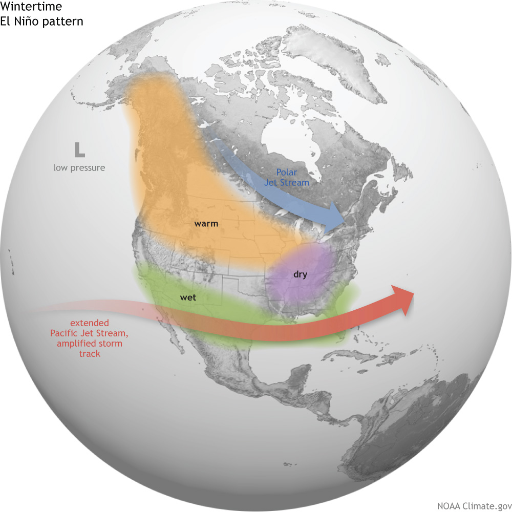
The connection between El Niño and Alabama begins in the tropical Pacific. Changes in ocean temperatures can alter where thunderstorms develop across the tropics. Those changes affect large-scale atmospheric circulation, which can eventually influence the position and strength of the jet stream across North America.
Think of it as a chain reaction. The Pacific Ocean does not directly determine Alabama's weather, but it can rearrange the larger atmospheric pattern in ways that make some types of weather more or less likely here.
These effects are most important for Alabama during the cooler months. During El Niño winters, the jet stream typically becomes stronger and shifts farther south across the United States, favoring a more active storm track across the southern U.S.
That is why, when we talk about what El Niño could mean for Alabama, the focus is primarily on late fall through winter. El Niño has much less influence on our summer weather, although changes in tropical activity can play a role during the fall hurricane season.
What are the current El Niño Conditions?
El Niño conditions are already present and strengthening.
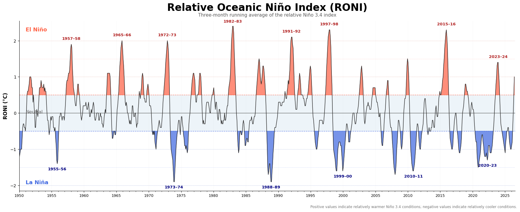
NOAA's August update reported that sea-surface temperatures in the Niño 3.4 region were about 1.8°C above normal. Forecasters expect El Niño to continue strengthening through the remainder of 2026, with a 97% chance that it will persist into early spring 2027.
While the likelihood of El Niño persisting is high, what has arguably garnered the most attention is the potential strength of this event. NOAA currently estimates an 81% chance of a very strong El Niño during October–December.
So, what does "very strong" actually mean? And what about the term you may have heard in the news lately: "super El Niño?"
What Is a "Super El Niño?"
“Super El Niño!” “Godzilla El Niño!” Our news feed is flooded with this phrasing.
It sounds dramatic, but "super El Niño" is not an official scientific category, and certainly not "Godzilla El Niño."
Roughly speaking, when the sea-surface temperatures reach 1.5°C above normal it is considered strong, while an event reaching around +2.0°C above normal is often described as very strong or historically strong. Only a handful of El Niño events since 1950 have reached that very strong level, including the major events of 1972–73, 1982–83, 1997–98, and 2015–16.
This year has a good chance of being one of the strongest, if not the strongest, on record. Stronger El Niños generally produce a stronger atmospheric response and can increase our confidence in some typical El Niño teleconnections. Even so, a very strong El Niño does not guarantee a particular outcome in Alabama.
So, What Does El Niño Mean for Alabama?
The first thing to keep in mind is that El Niño has very little direct influence on Alabama's summer weather.
ENSO's strongest and most consistent influence on the United States occurs during the cooler months, particularly November–March. So even though El Niño is already present, we should not attribute our hot, dry, or wet conditions this summer to El Niño.
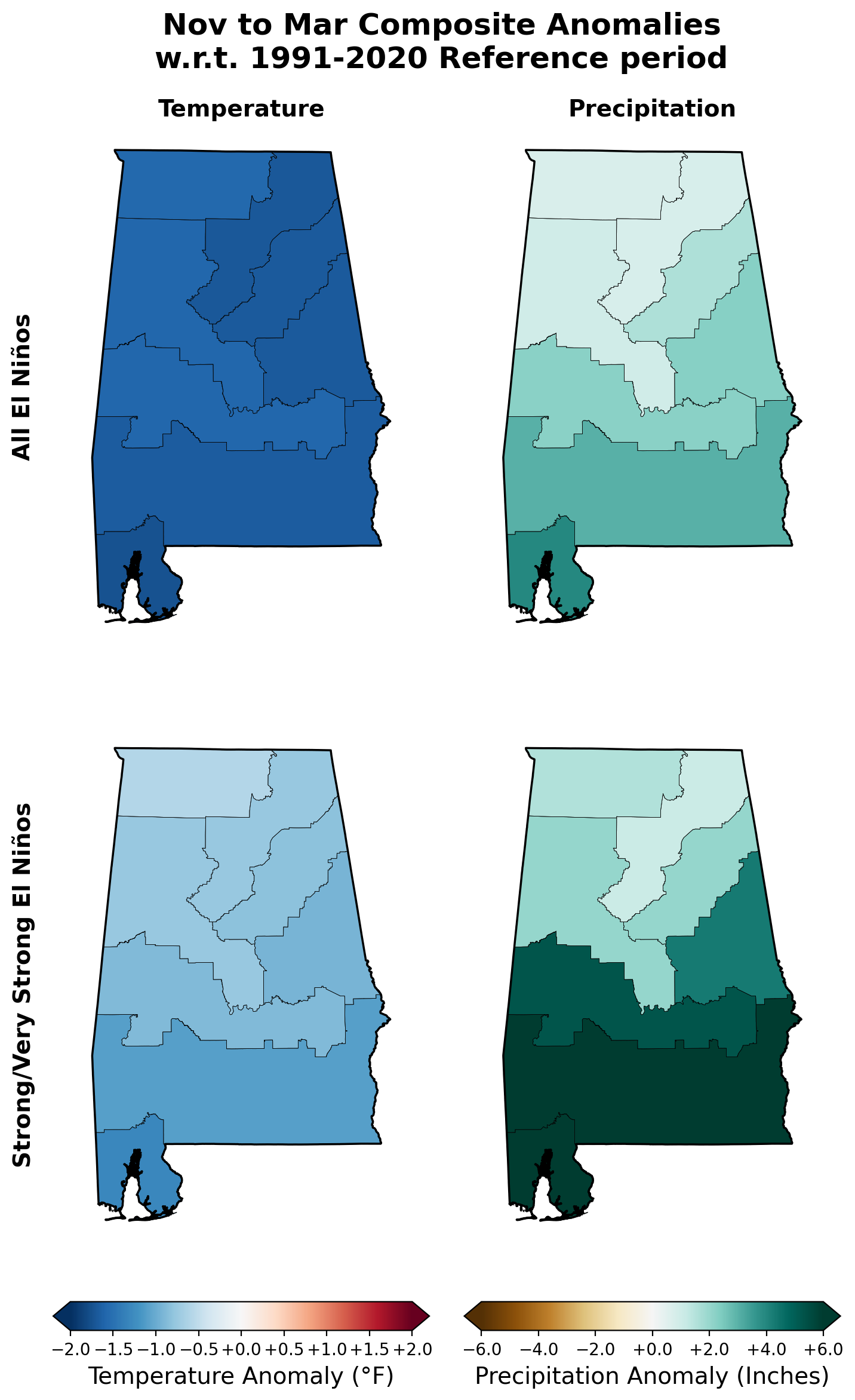
By late fall and winter, however, the El Niño signal becomes more noticeable. Historically, El Niño winters tend to favor wetter-than-normal conditions across the Southeast, including Alabama. The signal is generally strongest across southern portions of the state, while the historical relationship becomes somewhat weaker and more variable farther north.
Temperature also shows a signal, generally leaning cooler during El Niño winters across the Southeast, although the temperature relationship is weaker than precipitation.
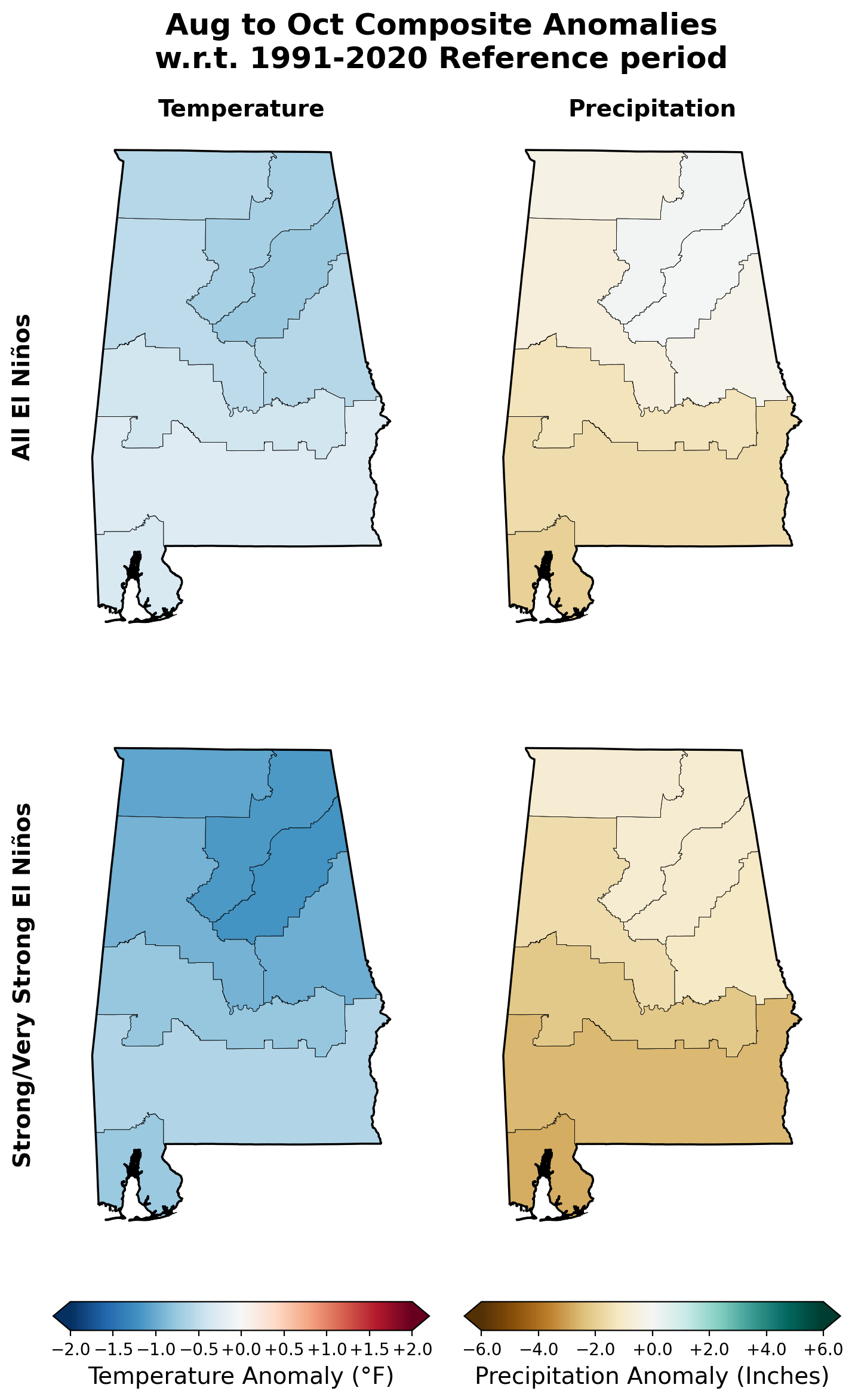
Looking at the top panel of Figure 4, you can see that for an El Niño year, Alabama is roughly about 2 degrees cooler and about 1-3 inches above normal on average. For a state that gets roughly 20 inches of rain during this period, that’s not too impressive.
Because this year's El Niño could become unusually strong, it is useful to look at what happened during previous strong and very strong events. The bottom panel of Figure 4 shows the handful of strong or very strong El Niño events that have occurred over the past 75 years. Although there have only been seven such events, the precipitation signal is a bit stronger. South Alabama averages more than 6 inches of precipitation above normal during these events!
These maps are probably the best way to think about ENSO in Alabama. They show a historical tendency, not a guarantee. Indeed, droughts can still happen during an El Niño. The major drought of 2006-2007 actually occurred during an El Niño year.
There will always be El Niño winters that do not look like the average El Niño winter. Other climate patterns, shorter-term atmospheric variability, and individual storm systems continue to play major roles in determining Alabama's weather.
The bottom line: El Niño tilts the odds; it does not determine the outcome.
What About Hurricanes?
Here, the relationship is somewhat different. El Niño can influence the Atlantic hurricane season, even though its strongest and most consistent influence on Alabama generally does not arrive until winter.
El Niño tends to increase upper-level winds over portions of the tropical Atlantic, creating stronger vertical wind shear. Strong wind shear makes it more difficult for tropical systems to organize and strengthen. As a result, El Niño generally favors less Atlantic hurricane activity than La Niña.
So, what does that mean for Alabama during hurricane season? When we look at rainfall and temperature patterns during the peak of hurricane season, August–October, El Niño tends to be associated with somewhat drier conditions across Alabama.
That does not mean Alabama, or anywhere else along the Gulf or Atlantic coasts, is protected from hurricanes during an El Niño year. It only changes the overall environment in which tropical systems develop. A single hurricane can still make for a very consequential season. In fact, one of the most impactful hurricanes to make landfall in Alabama, Hurricane Andrew in 1992, occurred during an El Niño year.
Does El Niño Mean More Snow for Alabama?
This one is much harder to tease out, in part because snow is already pretty rare in Alabama.
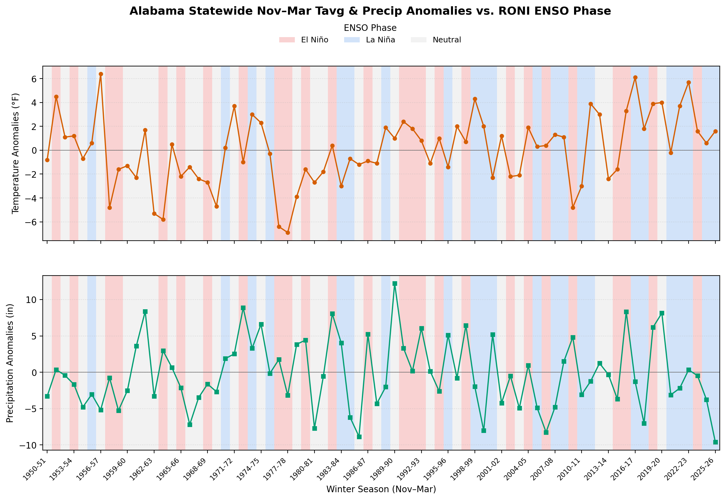
A stronger southern storm track can provide more opportunities for winter precipitation, and as the plots in Figure 7 show, El Niño winters also tend to be somewhat cooler on average. That might sound like a good setup for snow, but in Alabama, getting snow requires the cold air and moisture to line up at exactly the right time.
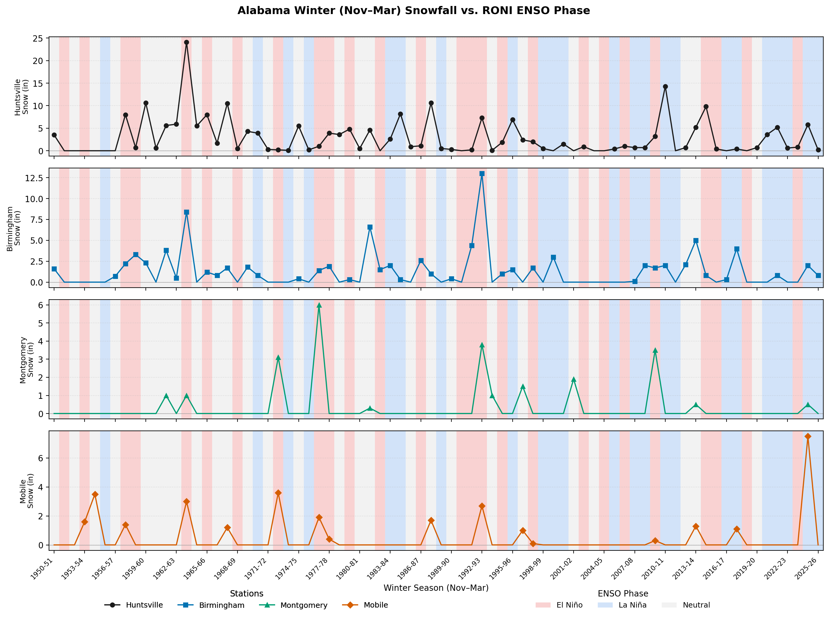
Some of our larger historical snow events illustrate the problem. The blizzards of 1964 and 1993 both occurred during weak El Niño conditions. But there have been many more El Niño winters than there have been blizzards. More recently, the Gulf Coast snowstorm that brought more than 7 inches of snow to Mobile occurred during a weak La Niña. In other words, major Alabama snow events have occurred during all phases of ENSO.
There is some hint of a signal in the historical data, with El Niño years tending to be slightly snowier in places like Birmingham and Montgomery. But the relationship is weak, and certainly not strong enough to say that an El Niño winter guarantees a snowy winter.
So while ENSO can influence the broader winter pattern, there isn't a simple "El Niño = snowier Alabama" relationship.
But for the snow lovers, there is at least a little reason for optimism. El Niño can favor a more active southern storm track, and historically, some locations in Alabama have seen slightly more snow during El Niño winters. That certainly doesn’t guarantee snow, but it may give us a few more opportunities for the right ingredients to come together.
What About Frost and Freezes?
There isn't much of an ENSO signal here either.
Our previous analysis of Alabama's last spring frost and freeze dates found little relationship between ENSO and when the final frost or freeze occurs. In Mobile, El Niño winters were associated with slightly later frost and freeze dates overall, but the differences are typically on the order of days rather than weeks. This is another good example of why we shouldn't try to use ENSO to predict every aspect of our local weather.
So, What’s the Bottom Line for Alabama?
El Niño is one of the most important sources of seasonal climate predictability we have, but its influence varies considerably by location and season.
If you remember only a few things about El Niño and Alabama, remember these:
- Summer: El Niño has little influence on Alabama's summer temperature or rainfall.
- Late fall and winter: This is when El Niño's influence becomes much more relevant, particularly from December through February.
- Rainfall: El Niño generally tilts Alabama toward wetter winter conditions.
- Temperature: El Niño winters tend to be somewhat cooler across Alabama, although the temperature signal is weaker and less consistent than the precipitation signal.
- Strong El Niño events: Very strong events increase the likelihood of a wetter winter, but it’s still not a guarantee.
- Hurricanes: El Niño generally suppresses Atlantic hurricane activity, but it does not eliminate the risk of hurricanes affecting Alabama.
- Snow and freezes: Some of Alabama’s biggest snow storms came during an El Nino year, but on average there is little signal for a snowier winter. There is no clear signal for the timing of frost and freezes in Alabama.
So, does the developing El Niño tell us something about Alabama's upcoming winter?
Yes, but not as much as some headlines might suggest.
It gives us a useful piece of the seasonal forecast puzzle and tilts the odds toward some outcomes, particularly wetter winter conditions, but Alabama's weather will ultimately be determined by much more than the temperature of the tropical Pacific.